
The intent of the first experiment is to provide a
first comparison of how well regional models represent aggregate
characteristics of weather
events in a simulation long enough to include many such events, i.e.
resolve climate. To this end, the experiment is designed to be relatively
simple to perform and diagnose thereby facilitating wide-spread
participation and the establishment of a framework for ongoing
intercomparison. The experiment will contain the strong climate signals of persistent extreme
events, which are expected to simplify the intercomparison by focusing diagnosis
on dominant processes during these events.
The initial experiment focuses on a
primarily agricultural region with significant vulnerability to growing
season precipitation, a problem common to most developing countries.
Accordingly, one emphasis of the intercomparison will be diagnosing the
simulation of hydrologic processes. In order to complement related
research programs, the initial experiment is also designed to overlap with
activities of COMPARE, GEWEX (specifically G-NEG and GCIP) and AMIP.
The first experiment will focus on the central United States, a region of intense cultivation containing a major watershed, the Mississippi River basin. It is a region that has experienced episodes of both extreme drought and extreme flooding within the past 10 years. This region is also the focus of GCIP and planned activities by G-NEG.
Period
The first experiment will contain two periods: the summer of 1988
drought (Expt. 1a) and the summer of 1993 flooding (Expt. 1b). Experiment
1a emphasizes thermal processes, whereas Experiment 1b emphasizes
processes of the water cycle. Initial simulation and diagnosis will focus
on the summer of 1988, but the coupled diagnosis of opposite extremes will
constitute a more complete analysis of the systematic behavior of participating models.
Simulations will be initialized using gridded analyses for 15 May 1988 and
1 June 1993 and will last 60 days. The starting dates represent times by
which persistent circulation features for each summer had become established.
The simulation domain will consist of two parts: a forced outer frame
and a "free" inner domain. Diagnostics will be computed for the
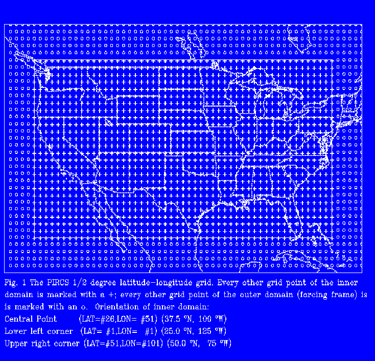
inner domain. The standard inner domain will be given by a 51 (N-S) x 101
(E-W) lat-lon grid with 1/2 degree resolution, with the central point
located in the middle of the U.S. (lat. grid #26, lon. grid #51) = (37.5
N, 100 W) (Fig.
1).
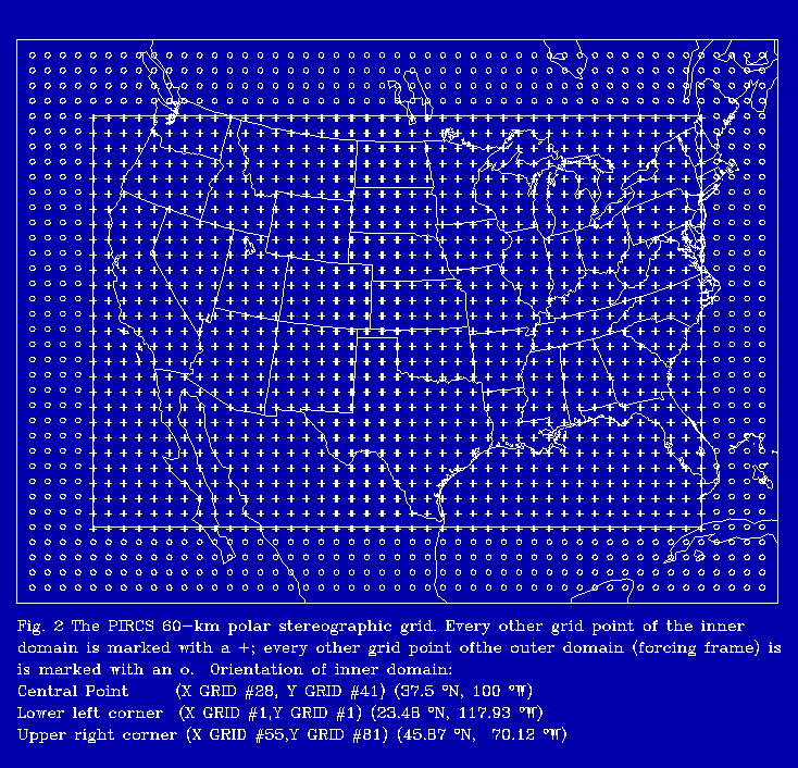
The PIRCS support staff has designed a nearly equivalent inner domain
for models using:
Precise structure of the inner and outer domains may vary between
models depending on their numerical procedures. It is expected that
participants in the intercomparison will use the lateral boundary
conditions given in the outer frame as appropriate for their model and
that no model will include explicit external forcing within the domain
covered by the standard "free" grid.
In the vertical direction, each model will use its own coordinate, grid
and resolution: there is no standard vertical grid.
Atmospheric Initial and Lateral Boundary
Conditions
The PIRCS support staff will provide initial conditions for the simulation
domain described above from re-analysis output produced by the U.S.
National Meteorological Center. In order to facilitate the participation
of a wide variety of models, and guided by the COMPARE program, PIRCS will
distribute data on three grids: a background, global grid at 2 1/2 degree
resolution, forcing-frame (outer domain) data at 1/2 degree resolution on
the lat-lon grid, and forcing-frame data at 60 km resolution on the polar
stereographic grid. Data for lateral boundary conditions will be provided
every 6 hours.
The variables provided will be the horizontal wind components (u, v),
temperature T, specific humidity q, the surface pressure p_sfc of the
reanalysis model and the topography used by the re-analysis model. Data
will be provided at 25 mb resolution. PIRCS will provide the algorithm for
vertical interpolation of surface pressure to the individual model's
topographic height.
The PIRCS support staff will provide soil-moisture for initial conditions
and periodic ocean and lake surface temperatures for lower boundary
conditions. For a number of reasons, precise determination of the field of
soil moisture on each starting date will be difficult. The soil-moisture
conditions that will be distributed are intended to provide a consistent,
reasonably accurate initial condition for all models. Therefore, while
these values can be converted to units appropriate for each model, they
should not be adjusted toward drier or more moist conditions.
For simplicity, each modeling group is encouraged to use their model's
topography and land characterization procedures already established for
this region, if they exist. The PIRCS support staff, however, will provide
a reference topography and land-characterization dataset for participants
needing this information.
The choice of cumulus convection and radiation schemes is left to each
modeling group.
Modelers submitting output to PIRCS should read and adhere
carefully to the format for transmitting
model output to the PIRCS archive.
Primary diagnostics will consist of heat, moisture and energy budgets
on scales finer than typically resolved by global models. All spatially
varying output should be reported on the model's grid for the inner
domain. The PIRCS archive will collect from each participating group a
standard archive (Table 1). The archive
emphasizes mesoscale circulation and diurnal cycles of energy and moisture
fluxes at the surface. A supplemental data set (
Table 2) is also requested from those with the means to assemble it.
Participants will be strongly encouraged to save at their institutions
hourly histories of the prognostic variables. PIRCS requests that archives
contain sufficient history information so that comparisons that are either
unanticipated by PIRCS or that go beyond the scope of the initial
comparison may still be performed. Examples of the latter would include
analysis of vertical fluxes of heat and moisture generated by convection
and their impact on resolved dynamics and study of the interaction between
clouds in the planetary boundary layer (PBL), radiation and other PBL
processes.
For Expt. 1a (drought year), diagnostic emphasis for the
intercomparison will be on the evolution of the thermal processes across
the domain, as characterized by the surface and atmospheric thermal energy
budgets. A comparison of hydrologic processes for this case of weak
hydrologic cycle will also be performed, but it is expected that this
comparison in particular will not be complete until the strong hydrologic
cycle of the 1993 flood period is also simulated and diagnosed.
Questions and requests for further information should be sent to
gstakle@iastate.edu (Gene Takle)
--or--
gutowski@iastate.edu (Bill Gutowski)
--or--
rwarritt@iastate.edu (Ray Arritt)
--or--
panz@eas.slu.edu (Zaitao Pan)


Copyright/Trademark
Legal Notice